Transit Network
— Select a network —
Adana Metro (Adana)
Algiers Metro (Algiers)
Almaty Metro (Almaty)
Amsterdam Metro (Amsterdam)
Ankara Metro (Ankara)
Athens Metro (Athens)
Atlanta Metro (MARTA) (Atlanta)
Baku Metro (Baku)
Baltimore Metro Subway (Baltimore)
Bangkok BTS Metro (Bangkok)
Bangkok MRT Metro (Bangkok)
Barcelona Metro (Barcelona)
Beijing Subway (Beijing)
Belo Horizonte Metro (Belo Horizonte)
Berlin U-Bahn Metro (Berlin)
Bilbao Metro (Bilbao)
Boston MBTA Subway (Boston)
Brasília Metro (Federal District)
Brescia Metro (Brescia)
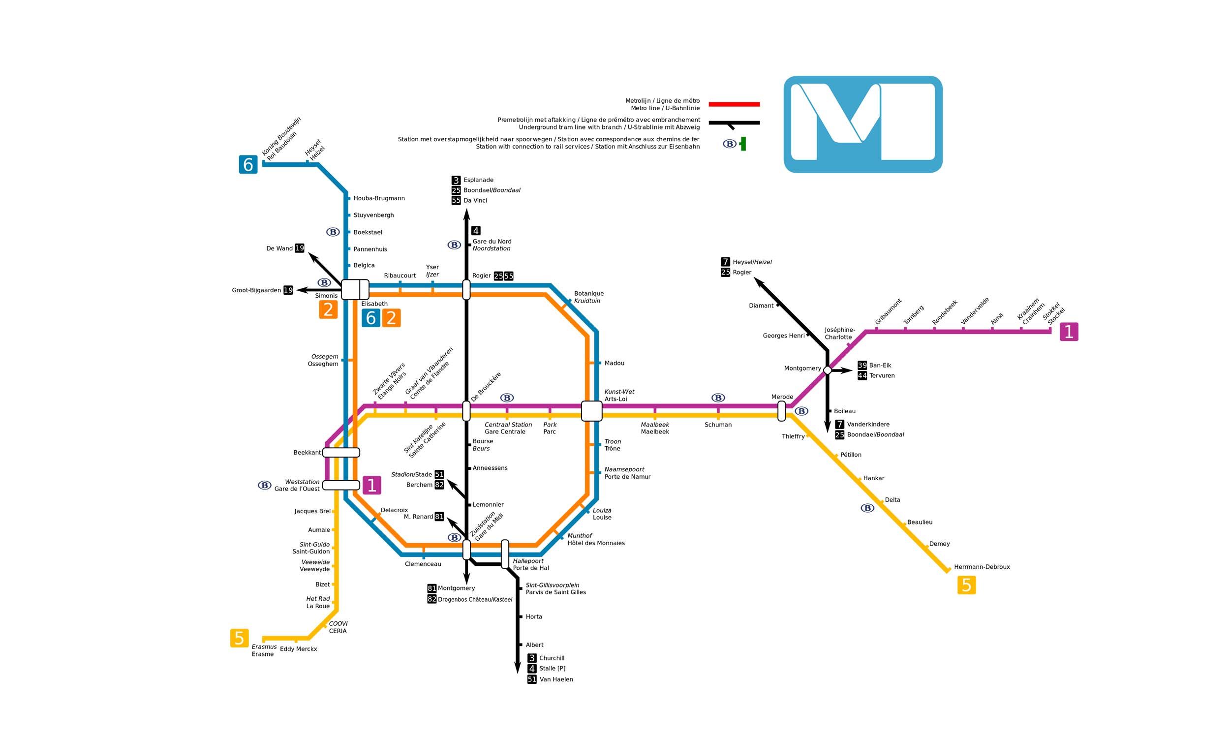
Brussels Metro (Brussels)
Bucharest Metro (Bucharest)
Budapest Metro (Budapest)
Buenos Aires Underground (Buenos Aires)
Bursaray Metro (Bursaray)
Busan Metro (Busan)
Cairo Metro (Greater Cairo)
Caracas Metro (Caracas)
Catania Metro (Catania)
Changchun Subway (Changchun)
Changsha Metro (Changsha)
Changzhou Metro (Changzhou)
Chengdu Metro (Chengdu)
Chicago \L\ (Chicago)
Chongqing Metro (Chongqing)
Copenhagen Metro (Copenhagen)
Daegu Metro (Daegu)
Daejeon Metro (Daejeon)
Dalian Metro (Dalian)
Dhaka Metro (Dhaka)
Dnipro Metro (Dnipro)
Doha Metro (Doha)
Dongguan Metro (Dongguan)
Dubai Metro (Dubai)
Fortaleza Metro (Fortaleza)
Foshan Metro (Foshan & Guangzhou)
Fukuoka City Subway (Fukuoka)
Fuzhou Metro (Fuzhou)
Genoa Metro (Genoa)
Glasgow Subway (Glasgow)
Guangzhou Metro (Guangzhou)
Guiyang Metro (Guiyang)
Gwangju Metro (Gwangju)
Hamburg U Metro (Hamburg)
Hangzhou Metro (Hangzhou)
Hanoi Metro (Hanoi)
Harbin Metro (Harbin)
Hefei Metro (Hefei)
Helsinki Metro (Helsinki)
Hiroshima Metro (Hiroshima)
Hohhot Metro (Hohhot)
Hong Kong MTR (Hong Kong)
Honolulu Skyline (Honolulu)
Incheon Subway (Incheon)
Isfahan Metro (Isfahan)
Istanbul Metro (Istanbul)
İzmir Metro (İzmir)
Jabodebek LRT (Greater Jakarta)
Jakarta LRT (Jakarta)
Jakarta MRT (Jakarta)
Jinan Metro (Jinan)
Jinhua Rail Transit (Jinhua)
Kaohsiung Metro (Kaohsiung)
Kazan Metro (Kazan)
Kharkiv Metro (Kharkiv)
Kobe Subway (Kobe)
Kuala Lumpur Rapid Rail (Kuala Lumpur)
Kunming Metro (Kunming)
Kyiv Metro (Kyiv)
Kyoto Subway (Kyoto)
Lagos Metro (Lagos State)
Lahore Metro (Lahore)
Lanzhou Metro (Lanzhou)
Lausanne Metro (Lausanne)
Lille Metro (Lille)
Lima Metro (Peru)
Lisbon Metro (Lisbon)
London Underground (London)
Los Angeles Metro (Los Angeles)
Luoyang Subway (Luoyang)
Lyon Metro (Lyon)
Macau Light Metro (Macau)
Madrid Metro (Madrid)
Manila Metro Rail Transit (Manila)
Marseille Metro (Marseille)
Mashhad Urban Railway (Mashhad)
Mecca Metro (Mecca)
Medellin Metro (Medellín)
Mexico City Metro (Mexico)
Miami Metrorail (Miami)
Milan Metro (Milan)
Minsk Metro (Minsk)
Monterrey Metro (Monterrey)
Montreal Metro (Montreal)
Moscow Metro (Moscow)
Munich U-Bahn Metro (Munich)
Nagoya Subway (Nagoya)
Nanchang Metro (Nanchang)
Nanjing Metro (Nanjing)
Nanning Metro (Nanning)
Nantong Metro (Nantong)
Naples Metro (Naples)
New Taipei Metro (New Taipei City)
New York City Subway (New York)
Ningbo Metro (Ningbo)
Nizhny Novgorod Metro (Nizhny Novgorod)
Novosibirsk Metro (Novosibirsk)
Nuremberg U-Bahn Metro (Nuremberg)
Osaka Metro (Osaka)
Oslo Metro (Oslo)
Palembang LRT (Palembang)
Panama Metro (Panama)
Paris Metro (Paris)
PATCO Speedline (Philadelphia)
Porto Alegre Metro (Porto Alegre)
Prague Metro (Prague)
Puerto Rico Tren Urbano (Tren Urbano)
Pyongyang Metro (Pyongyang)
Qingdao Metro (Qingdao)
Recife Metro (Recife)
Rennes Metro (Rennes)
Reseau Express Metro (Greater Montreal)
Rio de Janeiro Metro (Rio de Janeiro)
Rome Metro (Rome)
Rotterdam Metro (Rotterdam)
RTA Rapid Transit (Cleveland)
Saint Petersburg Metro (Saint Petersburg)
Salvador Metro (Salvador)
Samara Metro (Samara)
San Francisco BART (California)
Santiago Metro (Santiago)
Santo Domingo Metro (Santo Domingo)
Sao Paulo Metro (São Paulo)
Sapporo Municipal Subway (Sapporo)
Sendai Subway (Sendai)
Seoul Subway (Seoul)
SEPTA Rapid transit (Philadelphia)
Shanghai Metro (Shanghai)
Shaoxing Metro (Shaoxing)
Shenyang Metro (Shenyang)
Shenzhen Metro (Shenzhen)
Shijiazhuang Metro (Shijiazhuang)
Shiraz Metro (Shiraz)
Singapore MRT (Singapore)
Sistema de Tren Electrico Urbano (Guadalajara)
Sofia Metro (Sofia)
Stockholm Metro (Stockholm)
Suzhou Metro (Suzhou)
Sydney Metro (Sydney)
Tabriz Metro (Tabriz)
Taichung Metro (Taichung)
Taipei Metro (Taipei)
Taiyuan Metro (Taiyuan)
Taizhou Metro (Taizhou)
Taoyuan Metro (Taoyuan)
Tashkent Metro (Tashkent)
Tbilisi Metro (Tbilisi)
Tehran Metro (Tehran)
Tianjin Metro (Tianjin)
Tokyo Metro (Tokyo)
Toronto subway (Toronto)
Toulouse Metro (Toulouse)
Turin Metro (Turin)
Tyne and Wear Metro (Tyne and Wear)
Urumqi Metro (Ürümqi)
Vancouver SkyTrain (Vancouver)
Vienna U-Bahn Metro (Vienna)
Warsaw Metro (Warsaw)
Washington Metro (Washington)
Wenzhou Metro (Wenzhou)
Wuhan Metro (Wuhan)
Wuxi Metro (Wuxi)
Xi'an Metro (Xi\'an)
Xiamen Metro (Xiamen)
Xuzhou Metro (Xuzhou)
Yekaterinburg Metro (Yekaterinburg)
Yerevan Metro (Yerevan)
Yokohama Municipal Subway (Yokohama)
Zhengzhou Metro (Zhengzhou)